Maps General Settings
The Maps General Settings section controls the main map setup for your WPResidence website.
From this section, you can choose the map system, add API keys, set the map starting point, control zoom, enable pin clusters, and manage the map height when maps are used in the Hero Media header.
Where to find Maps General Settings
Go to:
Theme Options > Maps > Maps General Settings
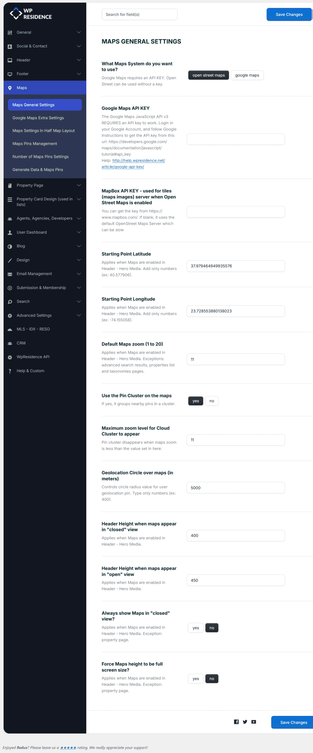
Choose the map system
Use the option What Maps System do you want to use? to choose the map provider for the website.
You can select:
- Google Maps – requires a Google Maps API key.
- OpenStreetMap – can be used without a Google Maps API key.
Related help:
Google Maps Extra Settings
Google Maps API Key
If you use Google Maps, you must add a Google Maps API key.
Add the key in:
Google Maps API KEY
The Google Maps JavaScript API v3 requires an API key to work correctly.
Related help:
How to get your Google API Key
MapBox API Key for OpenStreetMap tiles
This option applies when OpenStreetMap is enabled.
The MapBox API KEY is used for map tiles when OpenStreetMap is selected.
You can get a MapBox API key from:
https://www.mapbox.com/
Starting Point Latitude and Longitude
The Starting Point Latitude and Starting Point Longitude set the default center of the map when maps are used in the Header – Hero Media.
Add only numbers in these fields.
Examples:
- Latitude: 40.577906
- Longitude: -74.155058
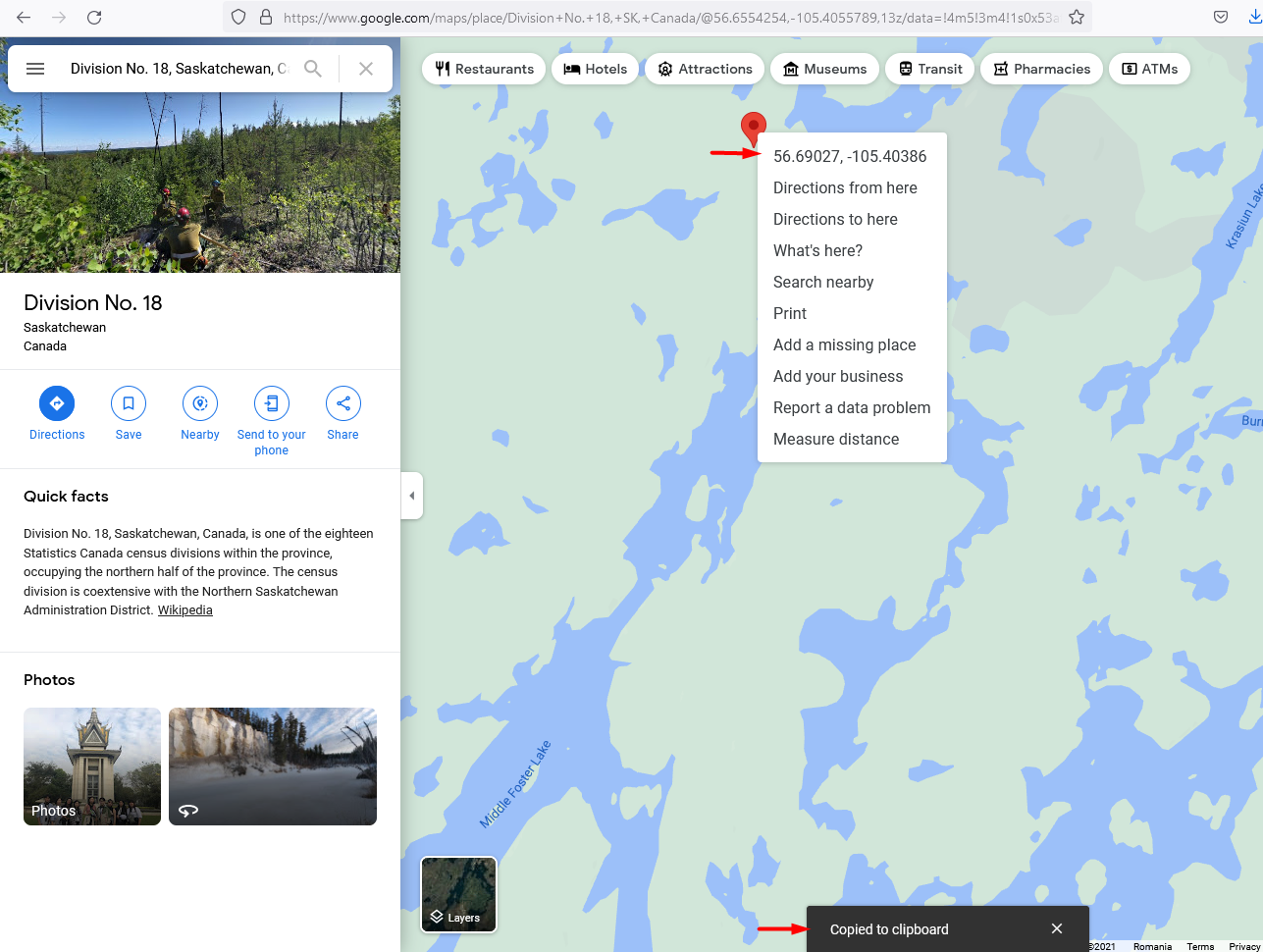
How to find Latitude and Longitude from Google Maps
- Open Google Maps.
- Search for the location you want to use.
- Right-click on the exact point on the map.
- Click the coordinates shown in the menu.
- The coordinates are copied automatically to your clipboard.
Default Maps Zoom
The Default Maps Zoom controls how close or far the map appears when it loads.
- 1 means zoomed out, close to world view.
- 20 means zoomed in, close to street level.
This setting applies when maps are enabled in the Header – Hero Media.
Pin Cluster settings
Use the Pin Cluster on the maps
This option groups nearby property pins into clusters.
- Yes – nearby pins are grouped together.
- No – all pins are shown individually.
Pin clusters are useful when you have many properties in the same area, because the map stays easier to read.
Maximum zoom level for Cloud Cluster to appear
This option controls when clusters stop showing and individual pins appear.
Example: if the value is set to 11, clusters disappear when the map zoom is higher than 11.
Geolocation Circle over maps
The Geolocation Circle over maps option controls the radius around the user geolocation pin.
The value is added in meters.
Example:
5000
This means the geolocation circle radius is 5000 meters.
Map header height settings
These settings apply when maps are used in the Header – Hero Media.
Header Height when maps appear in “closed” view
This controls the map height when the map is shown in closed/minimized view.
Header Height when maps appear in “open” view
This controls the map height when the map is shown in open/expanded view.
Always show Maps in “closed” view?
This controls whether the map starts in closed view.
- Yes – the map starts minimized.
- No – the map starts based on the normal map view settings.
Property pages are excluded from this option.
Force Maps height to be full screen size?
This option makes the map header use the full screen height.
- Yes – the map fills the screen height.
- No – the map uses the height added in the map height settings.
Property pages are excluded from this option.
Important notes
- Google Maps requires a Google Maps API key.
- OpenStreetMap can be used without a Google Maps API key.
- MapBox API key is optional for OpenStreetMap tiles, but it can help with faster tile loading.
- Starting Point Latitude and Longitude apply when maps are used in the Header – Hero Media.
- Advanced Search Results, Property List pages, and taxonomy pages can use map positioning based on the properties displayed.
- Closed/open map height settings apply to maps used in Header – Hero Media.
- Property pages are excluded from the closed view and full screen height options.